See which coastlines go under — before they do.
CORA is a desktop coastal risk analyzer. Load elevation data for any shoreline, run sea level rise scenarios, and measure what floods — buildings, hospitals, roads and people — then test whether a sea wall or restored wetland actually helps.
121 MB · Apple Silicon · macOS 11 or later · free and open source
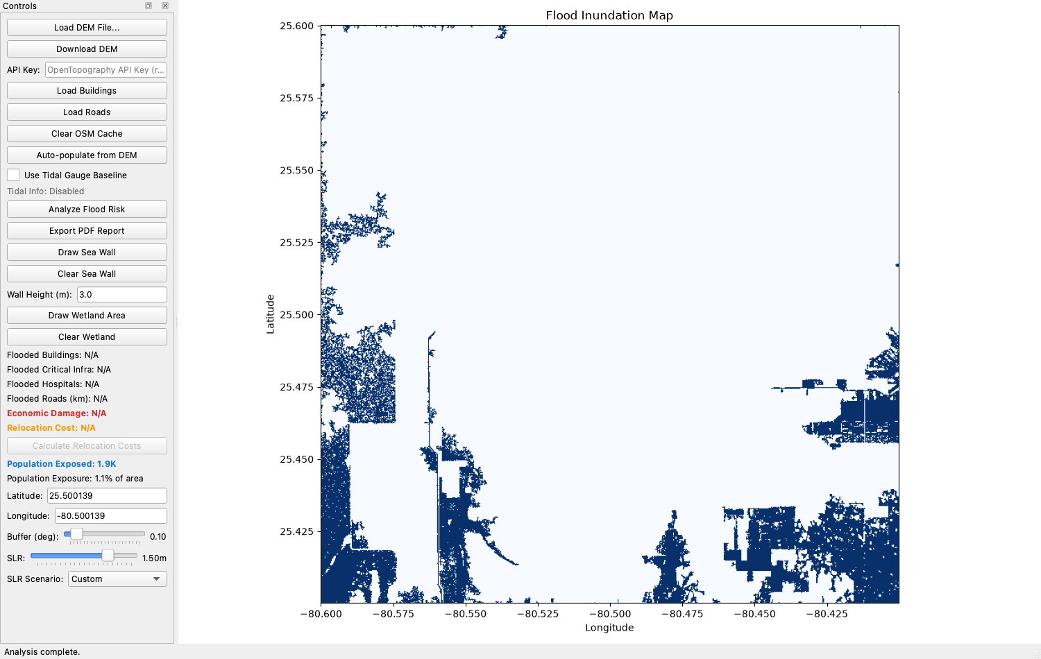
A worked example, in about a minute
The run shown above covers a 0.2° box over South Miami-Dade, Florida. CORA resolved the connected flood extent, then overlaid WorldPop data to count who lives inside it — the same numbers that go straight into the exported PDF report.
- Sea level rise modelled
- 1.5 m
- People inside the flood extent
- 1,853
- Of the study area's population
- 1.1%
- Copernicus elevation resolution
- 30 m
Recognition
CORA has been judged by scientists and engineers at three competitions.
First place
Canadian Meteorological and Oceanographic Society Award
Silver medal
York Region Science and Technology Fair
Silver medal
IgniteCS Expo — Senior Division, Data Science
Everything you need to make the case
CORA turns raw elevation rasters into the numbers a coastal adaptation argument actually rests on.
Connected flood modelling
Goes beyond a naive bathtub fill: only water with an actual path from the sea counts as flooded, so inland depressions aren't wrongly drowned.
Real tidal baselines
Pulls mean sea level from the nearest NOAA tidal gauge instead of assuming zero elevation, anchoring each scenario to locally measured water levels.
Population exposure
Overlays WorldPop demographic rasters to estimate how many people sit inside the flood extent, as a count and as a share of the study area.
Infrastructure impact
Pulls buildings and roads from OpenStreetMap, flags critical sites like hospitals, schools and fire stations, and reports what each scenario takes out.
Adaptation strategies
Draw a sea wall at a chosen height, or sketch a wetland restoration area with an evidence-based reduction factor, then re-run to see what it buys you.
Publication-ready reports
Export a PDF with parameters, methodology, impact and economic damage tables, and a high-resolution inundation map — ready to hand to a planning board.
From raster to recommendation
Four steps, all on your own machine. No account, no cloud processing, no per-analysis billing.
- 01
Load elevation data
Open a local GeoTIFF, or download Copernicus 30 m elevation for any bounding box straight from OpenTopography with a free API key.
- 02
Set the scenario
Pick a location and buffer, then dial in sea level rise from 0 to 2 metres — or choose a preset scenario — with an optional tidal gauge baseline.
- 03
Pull in what's at stake
Fetch buildings and roads from OpenStreetMap for the area. Results are cached locally, so re-running the same coastline is fast.
- 04
Test an intervention
Draw a sea wall or a wetland restoration polygon, re-run the analysis, and compare the flooded area, damage and exposure against the do-nothing case.
Download CORA
One disk image, no installer wizard, no dependencies to resolve. Python and every geospatial library it needs are already inside the app.
CORA 0.5.0 for macOS
CORA-0.5.0.dmg · 121 MB · released 2026-08-09
SHA-256 checksum
76a0713bae6165bb005e5dc5f910d36a099a9546de2a2205f38fd39f1c82f9b6Verify with shasum -a 256 CORA-0.5.0.dmg
Requirements
- macOS 11 (Big Sur) or later
- Apple Silicon Mac (M1 or newer)
- About 350 MB of free disk space
- Internet access for OpenStreetMap, tidal and population data
On an Intel Mac, Windows or Linux, run CORA from source instead — see the repository for the four-line setup.
First launch: macOS will block the app
CORA is not signed with a paid Apple Developer ID, so Gatekeeper refuses to open it on the first try and offers only a Move to Trash button. This is expected for independent software and does not mean anything is wrong with the download — verify the checksum above if you want certainty. To open it:
- 1.Drag CORA.app into your Applications folder.
- 2.Right-click (or Control-click) the app and choose Open.
- 3.Click Open again in the dialog that appears.
You only need to do this once. Settings, downloaded elevation tiles and caches are stored in ~/Library/Application Support/CORA.